
Satellite imagery provides critical insights into crop health and growth cycles over large farmland areas, offering farmers the ability to precisely monitor vast expanses. Detailed information on crop conditions helps identify issues such as disease and nutrient deficiencies early, supporting timely interventions and improved yields.
Advanced Monitoring with Hyperspectral Imaging
Hyperspectral imaging uses vegetation's unique spectral signatures to assess variations at a molecular level, capturing detailed chemical and biological traits of crops beyond traditional methods. This precision enhances decision-making and operational efficiency, improving crop quality and resource management.
For example, hyperspectral sensors can detect plant senescence, indicating declining vegetation health. Using Pixxel’s hyperspectral imagery over soybean fields in Iowa, USA, the Plant Senescence Index revealed stressed crop areas marked in red, signalling high vegetation stress levels. This enables farmers to intervene early and optimise crop outcomes.
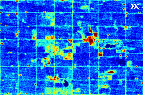
Crop areas in red reflected a high senescence index and indicated high vegetation stress. Source Pixxel
Optimising Harvesting Operations
Satellite imagery is essential for optimising the timing for biomass harvesting. By delivering near real-time data on crop growth and health, farmers can harvest at peak quality, maximising yield and minimising degradation. Space-borne hyperspectral sensors detect subtle light variations to identify chemical compounds linked to ripeness and moisture, enabling precise harvest predictions and improved biomass management.
Improving Yield Estimates
Accurate yield predictions are essential for planning and resource allocation. Satellite imagery offers detailed data on crop health, growth patterns, and land use, helping farmers align harvests with market demand. This reduces storage costs, prevents overproduction, stabilises prices, and enhances logistics for timely delivery, thereby supporting sustainability by minimising waste and environmental impact.
Hyperspectral imaging refines yield forecasts by evaluating crop growth stages, nutrient deficiencies, and diseases through data captured across hundreds of wavelengths. This insight enables accurate yield estimates, optimised procurement processes, and reduces environmental impact.
Enhancing Resource Allocation
Near real-time satellite data significantly improves resource management in biomass extraction. Continuous large-scale monitoring of crop conditions and environmental factors optimises water, pesticide, and fertiliser use. Hyperspectral satellite imagery captures plant physiology in detail, aiding in the detection of disease, nutrient deficiencies, and soil moisture levels. Enhanced precision in resource allocation reduces input costs and promotes sustainability.
Integration with Precision Agriculture
Integrating satellite imagery with precision agriculture techniques provides farmers with a broader view on crop conditions. A 2021 study revealed that adopting these technologies resulted in a 4% increase in yields, a 7% improvement in fertiliser efficiency, a 9% reduction in pesticide use, a 6% decrease in fossil fuel consumption, and a 4% reduction in water usage.
Hyperspectral imagery enhances precision farming by guiding machinery for targeted irrigation and fertilisation. Pixxel's hyperspectral satellites, delivering up to 50 times more data than traditional satellites, allow for accurate crop classification and efficient farm management. Some parameters and capabilities include:
- Plant Health: Evaluate chlorophyll levels, photosynthesis rates, and evapotranspiration.
- Soil Health: Analyse nutrient content, soil properties, and moisture levels.
- Effluent Monitoring: Identify seepages such as hydrocarbons and nutrient leaching.
- Early Crop Stress Detection: Recognise stress before visible symptoms appear, enabling timely interventions.
Environmental Impact Assessment
Monitoring environmental impact is crucial for aligning biomass production with sustainability. Hyperspectral imagery monitors factors like soil health, biodiversity, and greenhouse gas emissions, evaluating the effects of large-scale operations. Satellite data prevents resource depletion by tracking land-use changes, supporting soil conservation, and minimising deforestation.
Near real-time monitoring helps farmers adjust practices that could harm long-term environmental health. Balancing productivity with sustainability is vital, and satellite data-driven insights optimise land use while preventing resource overexploitation.
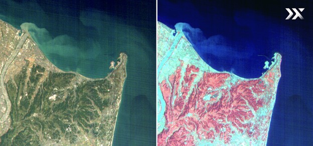
In this image captured by Pixxel’s HSI satellites over Shizuoka, Japan, we can observe the accurate classification of forest tree species. This allows for the precise assessment of biomass and carbon sequestration rates.
Cost Efficiency and ROI
Satellite imagery significantly reduces costs and boosts ROI in biomass procurement through efficient resource management and accurate monitoring. It minimises the need for on-site inspections by offering near real-time and non-invasive data. Hyperspectral satellites enhance ROI by:
- Boosting efficiency with precise data for optimising water, fertiliser, and pesticide use.
- Reducing waste through targeted management of inputs, minimising unnecessary resource expenditure.
- Improving yield accuracy for better harvest planning, reducing losses and maximising biomass output.
The Future of Agricultural Biomass Procurement
As satellite technology advances, its role in agricultural biomass procurement will continue to expand, driving greater efficiency and sustainability. Companies like Pixxel are driving innovation with advanced hyperspectral imaging satellites, providing high-resolution imagery and frequent updates that enable farmers and biomass producers to optimise operations and achieve sustainability goals.
Contact Pixxel’s sales team to learn how their solutions can benefit your agricultural organisation.
FAQs
- What is hyperspectral imaging?
Hyperspectral imaging captures images across hundreds of wavelengths, allowing detailed analysis of materials, such as crops, to assess their health and composition. - How does satellite imagery enhance biomass procurement?
Satellite imagery provides accurate data on crop health and growth, allowing farmers to optimise harvest timing and improve biomass yield predictions. - Can hyperspectral imaging improve biomass quality?
Hyperspectral imaging helps assess crop conditions and identify nutrient deficiencies, leading to better biomass quality and reduced degradation. - What are the environmental benefits of using biomass?
Biomass can reduce reliance on fossil fuels, lower greenhouse gas emissions, and support sustainable land management practices. - How do farmers use satellite data for biomass management?
Farmers use satellite data to monitor crop growth, optimise resource allocation, and align harvests with market demand, enhancing overall efficiency in biomass production.


